Cornwall has 25,000 acres of common land of which Bodmin Moor (17,000 acres) represents the most concentrated area. This unique granite upland covers 45,000 acres in total with most of the land lying at a comparatively low height of 200 to a 230 metres. Its modest height combined with its south westerly location means that it is one of the warmest and wettest uplands in Britain.
Bodmin Moor has been designated as an Area of Outstanding Natural Beauty (AONB) and the common land falls within the boundary of the Less Favoured Area. In addition the Bodmin Moor North Site of Special Scientific Interest (SSSI) covers the majority of the large commons whilst a number of smaller parcels south of the A30 are individually cited as SSSI's. The moorland falls within the areas of North Cornwall and Caradon District Councils.
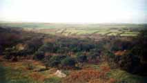
The topography of the area is influenced by both its geology and geomorphology and comprises of a series of gently sloping hills with depressions and shallow valleys. A number of wave cut platforms can be discerned in the landscape (300m, 230 - 250m and 150 - 200m) and the valley profiles have been shaped by the downward movement of soil under periglacial conditions during the last ice age. The higher ground is dominated by tors and granite strewn slopes (clitter) whilst the natural hollows are notable for their bogs and mires feeding a number of major water catchments.
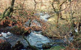 Rivers such as the De Lank, Witheybrook and Fowey rise on the moor and cut steep sided valleys as they leave the granite upland eroding into the surrounding slates or `killas'. These comparatively sheltered areas play host to sessile Oak dominated woodland whilst the higher ground is characterised by the modified grassland of the open commons.
The soils on Bodmin Moor have been influenced not only by the climate and underlying geology but also by mans influence over several thousand years. The effect of burning and grazing has created a series of comparatively poor soils ranging in character from the Iron pan stagnopodsols to the richer brown podsols of the periphery. This in turn has influenced the vegetation cover of the moorland and accentuated the distinctiveness of the landscape.
Average rainfall on the moor is around 1600 mm (180 days per year) per year with up to 1800mm on the highest ground. Mean temperatures vary with the lowest in winter at between 2-3 degrees C whilst the highest in the summer average between 19 - 20 degrees C. The prevailing wind is the moisture laden south westerlys which help to produce a humidity figure of 86% on Bodmin Moor.
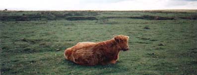
The farming communities which surround the commons actively use them for grazing and they make a vital contribution to the viability of their holdings. Although pasturage is the most frequently used right many commoners have are also registered the right of turbary and estovers.
 The common land that forms the moor is the key element in defining the landscape and has been gradually shaped and carved by mans activity over the past six thousand years. The upland has always been used as an area of seasonal grazing and only in comparatively recent times has enclosure and settlement crept up onto the higher moor. Today it can be difficult to distinguish between common land and areas of unimproved fenced grassland which abutt these open areas.
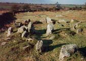
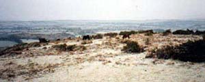
The open Moorland is best characterised by the open tracts of land to be found on the north and eastern edge of the moor. Here contiguous commons combine to give a feeling of openness and space with much of the land running at the 230 metre contour. Areas such as Davidstow, West Moor, East Moor and parts of the ancient manors of Hamatethy and Blisland provide extensive grassland in which to depasture cattle, sheep and ponies. Other equally large blocks include sections of the Cardinham moors, Shallow Water Common and on the southern edge Craddock Moor. Often the landscape can appear bleak and barren but the surface of the moor is littered with archaeology and the wetlands and mires add a subtle contrast to the seasonal colours. Elsewhere a change in the topography of the commons reduces the feeling of openness and combines with rolling slopes and shallow valleys to provide greater scale and height. The clitter strewn tors of Kilmar and Hawks Tor provide such a backdrop in direct comparison to nearby East Moor.
These large areas of common land tend to be well stocked throughout the year with cattle, sheep and ponies from a number of active commoners.
In contrast to the large open moorland in the north there are smaller pockets of common land which can be found scattered throughout the area. These are often dispersed amongst the medieval enclosed farmland and are bordere by hedges and crossed by roads. Many have in recent years been under grazed and display a mix of scrub, open grassland and woodland which provides an attractive mosaic of habitats. These smaller pockets tend to occupy the sheltered fringes of the upland implying that the moorland is more extensive than it actually is.
The south western corner of the moor is typical of these scattered commons with Manor Common, Kerrow Downs and Pendrift combining to intimate a much larger expanse of common land. Similarly on the southern fringes of the moor a host of smaller areas combine from Treslea to St. Cleer including Warleggan Down and Draynes Common.
Whilst some of the larger commons are stocked with cattle, sheep, and ponies others are only used seasonally or infrequently.
![]()
Many thanks to North Cornwall Heritage Coast and Countryside Service for all of the research on this page.
| The Moors | |
| The History of the Moors A brief outline of the history of Bodmin Moor from the Stone Age to present day |
 |
 |
Common Rights A detailed look at the history of the Rights of Common which have their roots in medieval times |
| The Lords of the Manor All of Bodmin Moor is privately owned and the landowners are known as the 'Lords of the Manor'. Here is a detailed look into the history and their rights. |
 |
 |
The Rivers of Bodmin Moor with its extensive areas of peat bog and clear feeder streams, Bodmin Moor is the source of many of the county’s principal rivers, the Fowey, Camel and De Lank, as well as the Ottery, Inny and Lynher which flow into the Tamar |
| Buy a map of the area online with www.amazon.co.uk | |
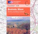
| Ordnance Survey Explorer Map 109 Bodmin Moor Click on the title above to take you straight to www.amazon.co.uk where you can purchase a copy of the definitive map for Bodmin Moor and have it delivered quickly and safely to your door for less than it will cost you to buy it in the high street. |
 |
| The Bodmin Moor Pages | ||||
|---|---|---|---|---|
| Natural History | Heritage | Welcome | Parishes & Villages | Tourist Information |
 |
The Bodmin Moor Pages are brought to you by |
 |
||
| www.southpenquite.co.uk | ||||