| Natural History | Parishes & Villages | |
| Heritage | Tourist Information |
St Breward Village Trail
 This tour around St. Breward provides a fascinating insight into a working village both in the past and present. The wealth of footpaths that link the moorland farms to the quarries, church and village provide other opportunities to discover the delights of this attractive moorland parish. Listed here are a few of the points along the trail, if you would like purchase the map with the full itinery then please call in at the village store which also doubles as a village information centre.
| 1. Mine Hill |
The whole of this hillside is marked with the remains of the l9th century mining operations for copper and other minerals i.e. old adits, capped shafts (one of which was used as an Observers Post in WW2) and the site of an old beam engine and water wheel.
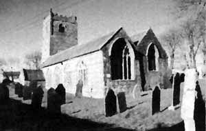
| 5. St Breward Parish Church |
St Breward Parish Church of the 6th century Cornish Saint Branwalader (means 'Raven Lord'). Built in the l2th century, probably on the site of an earlier Christian religious building. Inside 3 Norman columns and the font remain. It was much enlarged in the l5th century. Above the south door are the Royal Arms of William 3rd, dated 1700. Note the granite altar made and presented by the three St Breward quarries in 1985. Outside, over the porch, is a quaint sundial with the missing word inserted above the inscription.
| 6. Churchyard Cross |
Leaving the church, cross the lane to enter the graveyard and turn left to see the tall churchyard cross. The cross head dating from no earlier than the l0th century, and so pre-dating the church, was broken and has been reset on a massive granite shaft in recent times. From the church lane, return to the road and turn left.
| 7. The Old Inn |
The Old Inn which is at least 200 years old used to be the focus for village auctions and concerts. It is still a lively social centre today. Outside the Inn is a piece of carved stone thought to be part of the original shaft of the ancient Churchyard Cross. In the Inn car park there used to be two thatched cottages and a wagon house. In the early 1900s the publican used to take passengers into Bodmin in his wagonette on Saturdays. The open space in front of the Old Inn was used as a cattle and sheep market on the first Saturday in April (Spring Fair), July (Lamb Fair) and October (Autumn Fair). In the l9th century there was also a fair on the first Thursday after Midsummer day. To the right of the Old lnn is the Village Hall, which was the Village School from 1852 to 1950.
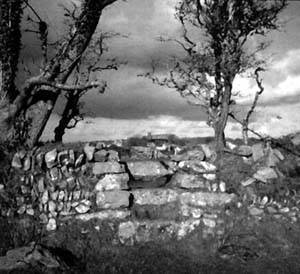
| 20. Bolts Quarry |
FoIlow the path uphill noting the impressive. views which open up behind you. As you climb you'will pass Bolts Quarry, typical of many in the locality where stone is taken from the nearest available place for house building. Follow the path through the yard of Bolt's Farm until you meet the road. Turn left uphill for about 200 yards to the seven-stepped granite stile on the left leading to the signposted footpath.
| 21. Taggarts Platt |
This path has magnificent views of the surrounding countryside from the north coast to St. Austell. This piece of land is called 'Taggarts Platt (referred to as Tiger's Platt by the children). As you look back you see Penvorder Cottages, a terraced row of twelve, built in 1899 for the De Lank Quarry workers.
| 22. Mount Pleasant |
Follow the path through the dry stone wall lane into Mount Pleasant and turn right uphill. The older houses are built of granite and slate. Newer houses use these materials chiefly for decoration.
| 23. Higher Penquite |
Higher Penquite (pen = end, quite= wood) has some fine old buildings. On the left l8th century Tremore and, on the right, the original Penquite farmhouse dated 1618 on the wall beside the arched granite doorway. Turn left through the first of two gates across the farmyard and follow the left hand hedge across the field. The reason for this unusual raised path is unknown.
| 24. Rough Tor Views |
Magnificent views of the moor are to be seen to the right over Alex Tor with Rough Tor and Brown Willy in the distance (the highest point in Cornwall). Continue along the path crossing four granite stiles until you arrive inthe lane at Lower Penquite.
| 25. Lower Penquite Cross |
The small cross was built into the wall here by some quarrymen to tease their colleague. He had put it to one side in the quarry after the stem had broken whilst he was working on it. Thereafter he had to pass it every day on his way to work.
| 31. St James’ Holy Well |
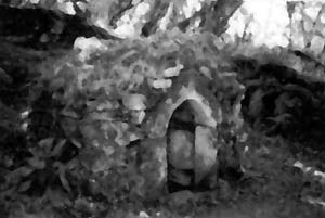 FoIlow the footpath downhill and through Sunnybanks being careful to secure the gate. This delightful path winds its way along a wooded sunken track. Eventually the medieval Holy Well of St. James appears on your left. It was last repaired in 1994 but the stream which used to supply its water was diverted in the last century as a result of nearby mining activity. It was thought to have curative properties. At the bottom of the lane turn right into the hamlet of Chapel.
| 32. Chapel |
The farmhouse to the right may incorporate some of the stone from the chapel of St. James licensed in 1419, from which the hamlet is named. Nothing else remains of the chapel except its association with the Holy Well. A short loop to the right will take you to the North Cornwall Aviaries located on Chapel Farm.
| 33. Coombe Mill |
Take the footpath signed to your left and proceed through the woodland and Coombe Mill until you reach the road. Turn right here and you will come across the clapper bridge at Coombe which is a fine example. It was built in the l9th century in place of the ford. On the grass verge beyond it is a cider press which used to be worked by a donkey turning the wheel. Also at Coombe was a water mill, one of many along the river Camel.
| 34. Limehead |
Carefully retrace your steps and follow the road uphill into Limbhead where you can rejoin the remainder of the walk at point 17.
If you are in the area and would like to walk the trail then you can pick up a leaflet with a map and all of the points of interest at the Village Store. They also have a wide range of information about the moors and the North Cornish coast.
| The Bodmin Moor Pages | ||||
|---|---|---|---|---|
| Natural History | Heritage | Welcome | Parishes & Villages | Tourist Information |
 |
The Bodmin Moor Pages are brought to you by |
 |
||
| www.southpenquite.co.uk | ||||